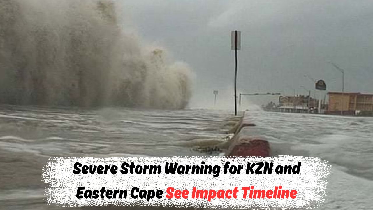
Storm Surge – South Africa’s coastal regions are bracing for a potentially destructive weekend as the Eastern Cape and KwaZulu-Natal (KZN) provinces face the imminent threat of a severe storm surge. The South African Weather Service (SAWS) has issued multiple warnings, including Level 6 and Level 8 alerts, forecasting extremely high waves, coastal flooding, gale-force winds, and widespread infrastructure risks from Friday through Sunday. This powerful weather system, driven by a deep low-pressure zone in the south Indian Ocean, is expected to produce swells of up to 6–9 meters, with the highest impact zones being areas between Port St Johns and Durban. Residents in low-lying coastal zones, informal settlements, and beachfront areas are especially urged to evacuate or prepare for rapid water rise, power outages, and road blockages. With the memory of past disasters like the 2022 KZN floods still fresh, municipalities are coordinating emergency response teams to monitor vulnerable regions. Beaches may be closed temporarily, and fishing or boating activities are strongly discouraged during this period. Emergency numbers and local disaster management offices are on standby to support those in danger. The following article outlines the full weather timeline, affected zones, severity levels, risk maps, departmental advisories, and everything you need to know to stay safe during this storm surge. Whether you’re a coastal resident, a business owner, or a traveler, here’s a complete guide to navigating this weekend’s storm safely.
Weather Timeline and Expected Storm Surge Duration
The storm surge is expected to develop rapidly over the weekend with key impacts concentrated in specific timeframes.
- Storm surge begins: Friday, 1 August 2025 – 18:00
- Peak surge impact: Saturday, 2 August 2025 – Early morning to late afternoon
- Persistent high tides and flooding risk: Sunday, 3 August 2025 – 05:00 to 19:00
Key Forecast Highlights:
- Wave heights reaching 6–9 meters off the coast
- High spring tide coinciding with surge on Saturday afternoon
- Gale-force winds exceeding 70 km/h in exposed regions
- Visibility reduced below 200 meters during storms
Affected Regions and Impact Levels
Areas between Port St Johns and Richards Bay face varying degrees of danger due to geographical exposure and elevation.
Storm Surge Risk Table – Coastal Towns Impact Projection
| Region | Alert Level | Expected Wave Height | Flooding Risk | Wind Speed | Key Time Period |
|---|---|---|---|---|---|
| Port St Johns | Red (8) | 8–9 meters | Very High | 70+ km/h | Saturday 5am–2pm |
| East London | Orange (6) | 6–7 meters | High | 60 km/h | Saturday 6am–3pm |
| Margate | Orange (6) | 7 meters | High | 65 km/h | Saturday 8am–4pm |
| Durban | Red (8) | 8.5 meters | Very High | 70 km/h | Saturday 9am–6pm |
| Richards Bay | Yellow (5) | 5.5–6 meters | Moderate | 50 km/h | Sunday 6am–12pm |
| Gqeberha | Yellow (4) | 5 meters | Moderate | 45 km/h | Friday night to Saturday |
| Port Edward | Red (8) | 8.5 meters | Severe | 70+ km/h | Saturday 7am–5pm |
Emergency Services Preparedness and Advisories
Local municipalities and national departments have activated emergency protocols to prevent large-scale damage and casualties.
- Disaster Management Units in Eastern Cape and KZN are fully operational.
- Schools along the coast may remain closed on Friday and Monday.
- Power utilities are reinforcing substations in high-risk zones.
- Medical facilities on standby for flood-related injuries and displacements.
- Temporary shelters set up in high-risk areas like Durban North and East London.
Emergency Contact Points and Support Numbers
| Department/Unit | Contact Number | Service Offered |
|---|---|---|
| SAWS (Weather Hotline) | 082 162 | Weather alerts and updates |
| KZN Disaster Management | 0800 205 005 | Emergency shelter, evacuation support |
| Eastern Cape Emergency Unit | 043 707 6444 | Coastal region disaster response |
| NSRI (Rescue Coordination) | 087 094 9774 | Maritime rescues and flooding incidents |
| Eskom (Electricity Faults) | 0860 037 566 | Power outage reporting |
| Local Municipal Support Desk | 0800 111 166 | Community alerts and emergency guidance |
Infrastructure, Business and Transport Disruptions
Many public and private sector services will be affected across the weekend due to predicted storm surges and urban flooding.
- Coastal roads such as Marine Drive (Durban) and R61 (Port St Johns) may become inaccessible.
- Public transport routes might be suspended in submerged or windy zones.
- Business activity in coastal towns is expected to halt during peak alerts.
High-Risk Facilities and Services Closures
Some businesses and recreational services will be shut temporarily to ensure public safety.
- Beachfront restaurants, hotels, and shops in Margate and Durban are closing from Friday afternoon.
- Schools, crèches, and colleges near the sea advised to suspend operations for 72 hours.
- Fuel stations in vulnerable flood zones preemptively closing pumps.
Transport Impact Table: Closure Forecast
| Mode of Transport | Status | Region Affected | Alternate Route Suggested |
|---|---|---|---|
| Minibus Taxis | Suspended | Durban South Coast | R102 Inland Route |
| Bus Terminals | Partial Closure | East London Central | Shuttle via Vincent Highway |
| Rail Services | Delayed | Port Elizabeth – Durban | Backup buses for short routes |
| Flights | Weather-Dependent | King Shaka Intl, Durban | Expect 3–5 hour delays |
Precautionary Measures for Residents
Residents in flood-prone and beachfront areas are urged to follow SAWS advisories strictly and evacuate early if needed.
Coastal Resident Action Plan
These steps can reduce risk of injury, loss of property, or being stranded:
- Elevate electronic equipment, documents, and valuables to higher ground.
- Seal doors and windows; use sandbags where possible.
- Switch off electrical mains before water level rises.
- Move livestock and pets to higher terrain.
- Avoid driving or walking through flood waters.
Safe Zone and Shelter Locations
Local authorities in both provinces have marked temporary shelters and high-ground evacuation points.
| Shelter Location | City/Town | Capacity | Contact Person |
|---|---|---|---|
| Bluff Community Hall | Durban | 350 | Mr. Luthuli – 061 xxx xxxx |
| Vincent Indoor Stadium | East London | 500 | Ms. Molefe – 083 xxx xxxx |
| KwaDwesi Civic Centre | Gqeberha | 300 | Mr. Nqoko – 082 xxx xxxx |
| Port St Johns Primary | Port St Johns | 400 | Mr. Xulu – 072 xxx xxxx |
What Not to Do During the Storm
Even experienced locals can make mistakes under panic. Here’s what to strictly avoid:
- Don’t drive through seawater-lashed roads.
- Don’t use gas stoves indoors without ventilation.
- Avoid using tap water if contamination is reported.
- Don’t share unverified weather updates or panic-inducing messages.
What SAWS and Experts Are Saying
SAWS meteorologists warn that this is not a typical spring tide event—it’s an amplified convergence of sea, wind, and moon cycle effects.
Expert Forecast Summary
- “This weekend’s storm surge combines intense swells and low-pressure currents that resemble mini-cyclonic behavior,” said Johan Steyn, SAWS marine forecaster.
- Residents inland up to 30km from shore may also feel impacts in form of wind gusts and minor flooding.
- Sea foam and debris may reach roads and buildings due to violent wave action.
Marine and Atmospheric Forecast Table
| Parameter | Friday | Saturday | Sunday |
|---|---|---|---|
| Wave Height | 4–6 meters | 6–9 meters | 5–6.5 meters |
| Wind Speed | 55 km/h | 70+ km/h | 50–60 km/h |
| Visibility | Moderate | Low (<200m) | Moderate |
| Rainfall | Light (5–10mm) | Heavy (30–50mm) | Medium (15–20mm) |
FAQs of Storm Surge
1. What is a storm surge and why is it dangerous?
A storm surge is a rise in seawater level caused by wind and low-pressure systems. It can lead to coastal flooding and structural damage.
2. Which day will be the most dangerous for Eastern Cape and KZN?
Saturday, 2 August 2025, will witness peak impact, especially between 5am to 6pm.
3. Can I still travel or go to the beach this weekend?
No. Authorities recommend avoiding all coastal travel and sea-facing areas from Friday evening to Sunday.
4. What happens if my home is flooded and I have no shelter?
You should immediately contact your municipal disaster office for nearby shelter options and transport.
5. Will power cuts and water supply issues occur?
Yes. Local authorities have warned about disruptions in electricity and water supply in affected zones.