Cape Town Cold Alert – Cape Town residents are being warned to prepare for a sudden and severe shift in weather as a powerful cold front barrels toward the Western Cape this weekend. According to the South African Weather Service (SAWS), an intense cold front will make landfall late Friday night, bringing icy winds, heavy rainfall, and a significant drop in temperatures across coastal and inland regions. This polar system is expected to be one of the most extreme weather events of the season so far. Meteorologists have emphasized that the cold front will not only impact Cape Town but will stretch across large portions of the Western Cape and parts of the Eastern Cape. Coastal communities should brace for rough seas, gale-force winds, and dangerously low temperatures, while inland areas might experience frost and even snowfall in higher altitudes. In light of the expected disruptions, local authorities are urging residents to take precautionary measures to secure property, ensure warmth, and avoid unnecessary travel during peak storm conditions. Emergency services are on high alert, and city officials are working to provide shelters for the homeless and vulnerable populations. The storm is likely to cause widespread delays in transportation, temporary power outages, and hazardous road conditions. As the weather system moves inland, the public is advised to monitor forecasts and warnings issued by SAWS closely.
What to Expect from the Cape Town Cold Alert
The upcoming weekend will see dramatic weather changes. Here’s what the experts are warning the public to prepare for:
- Sudden drop in temperatures across coastal and inland zones.
- Gale-force winds up to 70km/h along the coast.
- Widespread rainfall, especially Saturday and Sunday.
- Possibility of localised flooding in low-lying areas.
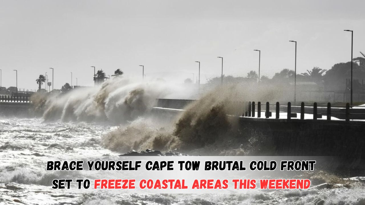
- Dangerous sea conditions with wave heights reaching 4 to 6 meters.
- Snowfall expected in mountainous regions.
- High risk for informal settlements and unprotected households.
Detailed Cape Town Cold Alert for the Weekend
The table below breaks down the predicted weather conditions across major areas in the Western and Eastern Cape:
| Region | Friday (Night) | Saturday (Day) | Saturday (Night) | Sunday (Day) | Wind Speed | Rainfall (mm) | Temperature (°C) |
|---|---|---|---|---|---|---|---|
| Cape Town | 12°C, Windy | 10°C, Rain | 7°C, Stormy | 9°C, Showers | 60-70 km/h | 25-40 mm | 7–12°C |
| George | 14°C, Breezy | 11°C, Showers | 8°C, Cold | 10°C, Rain | 50-60 km/h | 20-35 mm | 8–14°C |
| Paarl | 13°C, Cloudy | 9°C, Wet | 5°C, Frost | 7°C, Cloudy | 45-55 km/h | 20-30 mm | 5–11°C |
| Ceres | 10°C, Cold | 6°C, Rain/Snow | 3°C, Frosty | 6°C, Cloudy | 40-50 km/h | 15-25 mm | 2–9°C |
| Port Elizabeth | 16°C, Cloudy | 12°C, Showers | 10°C, Windy | 11°C, Rain | 55-65 km/h | 10-20 mm | 9–15°C |
| Beaufort West | 13°C, Cold | 8°C, Rain | 4°C, Frost | 7°C, Dry | 35-45 km/h | 5-10 mm | 3–10°C |
| Knysna | 15°C, Breezy | 11°C, Rain | 8°C, Cold | 10°C, Wet | 50-60 km/h | 15-30 mm | 7–13°C |
| Hermanus | 13°C, Windy | 9°C, Storm | 6°C, Wet | 8°C, Showers | 60-70 km/h | 25-40 mm | 6–11°C |
Cape Town Cold Alert – Emergency Preparedness Measures
To stay safe and warm during this intense cold front, residents should adopt the following measures immediately:
- Stock up on basic necessities: food, batteries, flashlights, and blankets.
- Secure outdoor furniture, bins, and equipment that can be blown away.
- Stay indoors during the peak of the storm.
- Avoid coastal areas and sea-facing routes during high tides and strong winds.
- Charge phones and keep emergency contact numbers accessible.
- Protect vulnerable populations – elderly, children, and pets – from exposure.
Cape Town Cold Alert – Public Services Response
Municipal services across the Western Cape are coordinating efforts to minimize the impact of the storm. Here are key actions being taken:
- Temporary shelters and warming centers set up for homeless residents.
- Emergency teams on standby for power outages and fallen trees.
- Stormwater systems cleared to reduce the risk of flooding.
- Hospitals and clinics remain fully staffed and operational.
- Road and transport services to monitor and report closures promptly.
Cape Town Cold Alert – Impact on Daily Life and Travel
Disruptions to transport and regular routines are expected throughout the weekend. Residents should plan accordingly to avoid being stranded or exposed to hazardous conditions.
Transportation Updates and Warnings
- Flights from Cape Town International may face delays or cancellations.
- Intercity bus and taxi services likely to be impacted by flooded roads.
- Road closures in flood-prone and mountainous areas expected.
- Coastal roads such as Chapman’s Peak Drive may be closed temporarily.
- Port operations might be slowed due to high winds and rough seas.
Safety Advisory from the South African Weather Service
The SAWS has issued Level 6 weather alerts across coastal zones. These include:
- Strong wind warnings across the Cape coastline.
- Localised flooding in the Cape Flats and Garden Route.
- Reduced visibility due to rain and mist on major highways.
- Risk of structural damage in exposed locations.
Communities Most at Risk
Certain populations are more vulnerable to the effects of extreme weather. Special attention should be given to:
- Informal settlements lacking proper insulation or drainage.
- Low-income households with limited heating resources.
- Individuals with chronic respiratory or heart conditions.
- Rural and farming areas likely to experience crop and livestock loss.
Measures for Vulnerable Areas
- NGOs and local relief groups are working with municipalities to distribute blankets, food parcels, and waterproof materials.
- Emergency call centers are being staffed 24/7 for reports of damage or rescue needs.
- Clinics in remote towns are being stocked with emergency supplies and medicine.
What Farmers and Pet Owners Should Know
Farmers in exposed areas are advised to take the following precautions:
- Move livestock to sheltered enclosures.
- Secure feed and prevent water freezing with insulated containers.
- Check heating equipment and fuel supplies for barns.
Pet owners should:
- Keep pets indoors or in insulated shelters.
- Avoid walking animals during high wind alerts or thunderstorms.
- Ensure water bowls are not left outside to freeze overnight.
Key Precautions During Extreme Weather
It’s crucial to be proactive when facing unpredictable winter weather. Following these simple yet effective tips can help reduce risk:
- Avoid driving in stormy or flooded areas.
- Do not attempt to cross fast-flowing water or rivers.
- Keep gas heaters and fireplaces well-ventilated.
- Dress in multiple layers and avoid alcohol which increases cold exposure risks.
Power Outages: What to Do
Power cuts are likely during heavy storms. Be ready by:
- Keeping torches and candles within easy reach.
- Using power banks for phones and essential electronics.
- Storing drinking water and easy-to-prepare food in advance.
- Turning off appliances to avoid power surge damage when electricity returns.
Local officials urge everyone to take the warnings seriously and prepare accordingly. The safety of families, homes, and communities relies heavily on timely action and awareness. Residents are advised to keep monitoring news updates and official weather advisories throughout the weekend.
FAQs – Cold Front in Cape Town
Q1: When will the cold front reach Cape Town?
A: The front is expected to hit Friday night and continue into Sunday evening.
Q2: Will there be snow?
A: Yes, snowfall is forecast in high-altitude areas like Ceres and Matroosberg.
Q3: Are schools and offices expected to close?
A: As of now, no closures announced, but local decisions may vary based on conditions.
Q4: How can I receive weather alerts?
A: Sign up for SMS alerts from SAWS or follow local municipal social media accounts.
Q5: What if I see flooding or fallen power lines?
A: Call emergency services immediately and avoid contact with water or exposed wires.